La Feste della Liberazione, celebrated on April 25th, is a national holiday in Italy. Unlike local feast days and idiosyncratic days off, it is a true national holiday. We don't have an equivalent holiday in the US because we have never been occupied and needed liberation. The closest day would probably be the 4th of July, our Independence Day. Italy has been occupied many times over the course of its 1000's of years of existence, but the unified country of Italy only came into being in the 1860's and didn't take its current borders until following WWI. However, the holiday effectively celebrates the end of WWII, so perhaps it is more closely related to our VE or VJ Days which are now celebrated in combination as Veteran's Day in the US. Finally, it is also a day to remember not only veterans of WWII, but also of all wars, sort of like our Memorial Day. A pretty all encompassing celebration.
So, what exactly were they celebrating liberation from? That is where the question becomes interesting and not just a little controversial. Italy, under the leadership of Mussolini and the Fascists, opportunistically joined WWII on the side of Germany at about the time France was falling and the UK was on the brink of going under, in other words, when they thought it was likely the Germans would prevail. Smart? No, not so smart. So, in mid-1943 with the start of the Allied invasion of Italy, the government wised up and switched sides. The King had Mussolini arrested, but he was sprung by the Germans and continued to lead the parts of Italy not under Allied control for almost two more years until late April of 1945. At that point he was caught, summarily executed and placed on display for all to verify his death. So, Liberation Day coincides with the final demise of Mussolini. Therein lies the controversy. Not all Italians thought that Mussolini was bad. In fact, his brand of Italian nationalism is still alive today. Hence, in some places the day is celebrated with great fanfare. But, in other places such as very conservative Viterbo, it is a low key event which doesn't engender a great deal of public support.
How did WE celebrate? Just before 9 AM the main streets of Via Garibaldi and Via Cavour were once again cleared of parked cars in preparation for a parade. Amy and I headed out to watch. Since it seemed like we would have to wait awhile for an actual parade, we took a walk over to the public gardens by Porta Fiorentina and then came back. I was all set to go get my camera to take pictures for this post when we realized that the parade and even the subsequent gathering was all over. The entire observation couldn't have taken more than 20 minutes. There appeared to be no public speaches and we can't even verify that there was any kind of marching band. So much for liberation. Unfortunately, most shops were closed for the holiday, but at least we got the day off from school and the Spring weather made it quite pleasant just to be out and about.
Thursday, April 26, 2012
Monday, April 23, 2012
Vitorchiano
Italy is divided in many ways. First, the country is divided into regions which are essentially states. Viterbo is part of Latium. Each region is made up of provinces. The city of Viterbo is the provincial capital of the province of Viterbo. Then, of course, there is the city or town you live in within the province, which is, of course, Viterbo.
Beyond civic divisions, there are also other descriptive names for different parts of Italy. In that way, the immediate area around Viterbo is known as Tuscia. We are deep in the area which was originally populated by the Etruscans. Our friends, the H-Ps, found a small book left in the apartment they live in by some previous SYA occupant. It details all of the little towns in the area, highlights what you can see, and indicates driving routes and distances from Viterbo. After our recent luck in locating the park on Monte Cimini and finding Tuscania, we decided to be more deliberate in exploring the area where we live. To that end, we found a period of sunshine and headed off to Vitorchiano, a small town about 10 km ENE of Viterbo.

My brief impression of Vitorchiano is cats and flowers. Unlike in Viterbo, residents have introduced green into the grey stone surroundings by extensive garden boxes.


The cats are everywhere. The only place I have seen a comparable number of wandering cats was in Civita di Bagnoreggio. You get the feeling they weren’t really feral. They seemed to be reasonably well cared for. They were just outdoor kitties. This shot of a little black boy sized just about right to fit in the palm of your hand almost earned him a ride home to Viterbo.

Sunday, April 22, 2012
Strike!
On Friday we were slated to take what was scheduled to be the 5th and final school trip of the year to Rome. One of those five trips had already been canceled due to the snow storms of February. Then, late Thursday night, we got a phone call canceling the trip for the next day. It seems that railroad workers had called a strike.
Strikes are commonplace in Italy. Unlike in the US where transportation, etc. are privately operated, huge swaths of services are covered by public workers. This includes all transportation such as trains and busses. Taxis drivers, while not public employees, are unionized and will also strike either on their own or in cooperation with other transportation unions. The school, when it goes to Rome, must travel by train – all 60+ people would fill a bus to more than overflowing. So this strike, which was confined to trains, meant we couldn’t go even though the buses were running. The intention is to inconvenience travelers to remind them of the importance of the job done by the train personnel. You don’t want to piss people off so badly that they have no sympathy for you. So, some trains were running. What it really meant was that service was not regular. You could end up on a later train than you wanted or stranded somewhere unexpected. Either situation would be unacceptable to the school as it traveled. For instance, where would you put up the entire school if they were stranded overnight in Rome and how would you find the thousands of euros to cover the unexpected expense? There is an entire website dedicated to announcements of upcoming strikes which are announced enough in advance to be able to give people time to prepare. Often strikes are cancelled or postponed which is why we were hoping to go and had to cancel at the last minute when it became obvious that the strike was on.
To be honest, Italians seem much more accepting of unions and strikes. They appear to understand that the people involved simply want fair working conditions and an opportunity to make a living. This is in contrast to the bitter anti-union sentiment being bandied about in the US. There is a particularly mean spirited sentiment against public employee unions and public employees in general – including school teachers. I feel this anger very deeply in Western Mass and, though I understand the frustration, I don’t see why people are so angry at individuals who in many cases are barely making a living.
Thursday, April 19, 2012
Tuscania
Recent weather has been cooler and more unsettled than is typical for this time of year. Winter was warmer and drier than normal, so the off again-on again showers and rain that we have had has been generally welcome. During a break in the clouds this weekend, we set off on a spur of the moment trip to the nearby town of Tuscania, located some 20 kilometers to the west of Viterbo. Tuscania is believed to have been settled in Neolithic times. It was definitely inhabited by the Etruscans as their tombs and other archeological remains dot the countryside and form the foundations of many buildings. The construction of the Via Clodia helped propel Tuscania as an economic and agricultural center during the first century BC. Remnants of Via Clodia can still be found as this excavation in the middle of town indicates.

For me, the overwhelming features which characterize the town are churches and fountains. Even more than Viterbo, there seems to be an old stone church pretty much wherever you walk in the Centro Storico. The most prominent of the churches is located a short distance outside the city wall. The Chiesa di San Pietro was built during the 8th century and substantially remodeled during the 11th and 12th centuries.

At one time it was contained entirely within a walled compound, accessed through this free standing gate which still remains.

One of the more unique features is this carving over the main entrance which sits atop a small loggia. Apparently, the area around this church was originally heavily settled, but the living spaces were abandoned following massive death during the Black Plague, leaving only the church in its current location outside the subsequent medieval walls.

There are many fountains within the walls, although fewer than in Viterbo. This one which has seven water spouts is near the gate where we entered. It is just around the corner from an extensive public laundry facility, so it is unlikely that it is actually a laundry, but its general shape doesn’t rule that out.

A more traditional fountain can be found in the Piazza del Duomo.

Compared to Rome, the pace of life in Viterbo is quite moderate. Perhaps like the difference between New York City or Boston and our home city of Springfield. In contrast, while only a few miles away from Viterbo, Tuscania was small-town quiet and serene. Granted, it was a Sunday afternoon, but one got the sense that life there was more peaceful and deliberate with lots of open, green spaces and fresh air.
Wednesday, April 18, 2012
Manarola (Cinqueterre)
Departing Pisa, we made our way up the coast to the city of La Spezia and then headed across to the Cinqueterre. These five small towns developed in relative isolation, connected only by a network of trails and then later by railroad. The land rises straight out of the water in this region so the towns are nestled into small ravines or cling to the cliffs and bluffs. They are now part of a national park, crisscrossed by hiking trails. We stayed in Manarola, the second town as counted from east to west. We stayed in the same rooming house we visited six years ago. Below is a picture taken from the window of our room.

The brightly painted houses are a signature of this region. The house we stayed at, not visible in the picture for obvious reasons, is the only purple house in town. The steeply sloped hillsides are terraced in such a way that would put even the Peruvians to shame. The principal crop of the region is grapes and we had several bottles of very nice, local, vino bianco. On the terraces to the right, they normally have a cross and the illuminated word “pace” (peace). Since we were there during holy week (we departed on Good Friday) they set up a series of figures for the Stations of the Cross.

During our previous visit it was full tourist season under a blazing August sun. This trip was far more laid back with weather that was just right for walking. In the view of the “harbor” below you can see a path bounded by a railing heading off some 20 meters above the water. This is the part of the primary path which connects the five towns.

Unfortunately, this sentiero basso, or lower trail, is not open due to a series of washouts which occurred during heavy rain last fall. That means, if you want to walk you have to walk through the mountains on the sentieri alti, or upper trails. The lower path to Corniglia, the third town, would normally take half an hour or less to walk. The upper path took almost three hours. You climb almost 400 meters at a pitch of close to 35 degrees then walk along the narrow terraces of grapes. The view is spectacular! At one point we had a view of Manarola to our left and Corniglia to our right.

The weather was … interesting… to say the least. The dark gray layer at the top of this picture is the cloud layer. While Corniglia is darkened by clouds, beyond it you can see the sun on the next bit of shore visible.

The bottom of the clouds was actually lower than us and at one point we were walking through it.

By the time we descended into Corniglia, it was sunny there as well. We lunched in Corniglia and then took the three minute train ride back to Manarola. I kid you not, 3 minutes instead of 3 hours, although they accomplished that by doing the entire trip underground in a tunnel. We spent two nights in Manarola and then returned to Viterbo to rest and get ready for the final push to the end of the school year.

All of the guidebooks tell a tale of five isolated towns, connected only by walking paths and a train. That was certainly the way it was years ago, but it is now a complete fabrication. Roads connect all of the towns in the hills above as I discovered while hiking the last time we were there. There is very limited parking, in Manarola there are no more than 60 pay spaces, so they can’t come any way near handling the huge influx of tourists who visit if they all drove. However, residents all have cars parked outside the limited access area and it is no more than 20 minutes drive from Manarola to a very large city (La Spezia). As it was the off season, we were able to snag a space with no problem. In fact, they weren’t even bothering to collect parking fees so we saved the 20 euros a day they would normally charge. If you arrive by train and spend all your time walking along the sentiero basso, then you might never realize the truth. However, once you start walking the sentieri alti the illusion is gone. The moral of the story is, if you visit and want the myth, stick to the lower path which will hopefully be repaired sometime soon.
Tuesday, April 17, 2012
Pisa
During our recent break, Amy and I spent a couple of midweek days traveling. Our first stop was Pisa. Neither of us had ever been there before to visit. Our only contact was almost six years ago when we passed through on the train on our way back to Rome. This time we were with car and, after a bit of getting lost and following signs for parking that faded away, we found a free space on a residential street and walked a kilometer or so to the walled Centro Storico.
Pisa has any number of decent museums, it is Italy after all, and the University of Pisa is the finest in all of Italy (sorry Bologna and Roma). But, people come to Pisa to see one thing and one thing only, the Leaning Tower of Pisa. Amy and I were no different. We, however, unlike most tourists, entered the Piazza del Duomo from the rear entrance nearer to the residential section of the city where we parked rather than the main entrance by the business district. That meant we were greeted immediately by the tower rather than having to run a gauntlet of kitsch selling shops. What can you say, it leans.

As a scientist, Pisa is a must-see stop for historical reasons if no other. It was here that Galileo formulated his ideas about freefall and did experiments with rolling objects on inclined planes which would later be co-opted into Newton’s first law of motion. Interestingly, historians of science are in fairly strong agreement that Galileo never did the famous public experiment of dropping objects with different masses from the tower to demonstrate that they reached the ground simultaneously rather than the heavier object arriving first. He definitely did experiments and reached the conclusion given. He may even have dropped things from the tower. There just isn’t evidence to suggest he hosted a grand public event.

The Piazza del Duomo contains three buildings set in a large open space which is entirely green at this time of year. The leaning tower is actually the bell tower of the duomo. There are some interesting carvings around the columns at the base including this one.

There is the duomo itself. When you enter as we did, you are facing the rear of the duomo as the bell tower was at the rear of the complex. When you make it to the front there are some nice doors of what is probably bronze.


The baptistery sits in front of the duomo. Here you have a radiant Amy with the baptistery in the background.

Finally, below is a picture of all three buildings to give you a perspective view. I tilted the camera slightly so that the tower is vertical and the rest of the picture slopes. Aren’t I clever!

It was a gray foreboding day in early April; showers began to fall as we were leaving. It is hardly peak tourist time. In fact, we were barely on the shoulder of tourist season. And yet, the piazza was packed with people creating long lines at everything. I can’t begin to imagine what it would be like during the heat of summer with thousands of your closest friends. All three of the buildings are open, for a hefty fee, including the tower itself. For quite awhile the tower was off limits but they managed to stabilize the building a decade or so ago and now allow small groups to visit and climb to the top. That was not to be. I had neither the patience to wait nor the desire to drop that much cash.
Wednesday, April 11, 2012
Pasqua e Pasquette
The week between Palm Sunday and Easter is an interesting time here in Viterbo. Students are on Easter Break, so there are no classes. Yes, it is referred to as Easter Break and, unlike in the US when the times for school breaks are dictated by teacher contract, this break always happens at Easter, even for us at the Schola Americana.
Knowing what will be open and what will be closed requires wisdom and experience well beyond that obtained by living here for a few months or even a few years. Some businesses are closed for the entire week. Others close early on Friday. As expected, everything is closed on Pasqua (Easter). That even includes the little bars and pastry shops which are normally open on Sundays. So far, so good. Then we come to the Monday following Easter. This day is also celebrated as a holiday, called Pasquette (Little Easter). Everything remains closed. It is traditional on this day for families to gather together for a picnic and, weather permitting, some outdoor time. So, not being ones to buck tradition, Amy the H-P’s and I packed a picnic lunch and went for a hike in the recreation area on Mt. Cimino outside Viterbo. There we discovered clear blue skies, well maintained trails, and very few people. It was an unexpected gem. We will return again whenever we need green space time to maintain our sanity.
Tuesday, April 10, 2012
Good Friday
We turned the corner onto the main road last Friday on our way to visit the H-Ps to discover notification of a temporary parking ban on Via Garibaldi and Via Cavour. This doesn’t directly affect us as we park in a lot outside the city walls, so it was not cause for panic. Instead, it signaled yet another street clearing procession through the center of town, this time as part of a celebration of Good Friday. The procession began a bit after 9 PM, well after dark, at the Chiese Santa Maria Nuova where St. Thomas Aquinas preached from an outdoor pulpit.


After brief prayers, a procession of clergy led a pair of wooden biers containing figures of a reclining Jesus followed by Mary in mourning through San Pellagrino, around the Fontana Grande, down Via Cavour and then concluding at the Piazza San Lorenzo, site of the Papal Palace. Along the route, spectators would fall in behind until there were hundreds of people walking in silence accompanied by the chants broadcast over portable speakers.

 The final ceremony at the duomo included a reenactment of the Crucifixion of Christ, complete with the flanking thieves and Roman soldiers. However, no nails were used.

Since I did not anticipate the celebration, I did not bring my camera. Thanks go to Carolyn for allowing me to use some of her pictures.


After brief prayers, a procession of clergy led a pair of wooden biers containing figures of a reclining Jesus followed by Mary in mourning through San Pellagrino, around the Fontana Grande, down Via Cavour and then concluding at the Piazza San Lorenzo, site of the Papal Palace. Along the route, spectators would fall in behind until there were hundreds of people walking in silence accompanied by the chants broadcast over portable speakers.


Since I did not anticipate the celebration, I did not bring my camera. Thanks go to Carolyn for allowing me to use some of her pictures.
Monday, April 9, 2012
Drinking Your Way Across Malta
My only previous experience with an island the size of Malta is Aruba. Nothing grows on Aruba. Everything from building materials to food has to be shipped in. There is absolutely no source of fresh water on Aruba. They run a huge desalination plant to provide fresh water for residents and tourists. So, I was actually somewhat surprised that there is significant agriculture on Malta. In particular, they grow grapes well. While it is true that we sipped more than a few glasses of French and Italian wine, we also sampled quite a number of local wines produced on Malta and, for our Gozo lunch, a Gozo wine. They were all quite good, but one of the ones we agreed we liked the best was purchased from a veggie stand in Manikata near our hotel. It was a nice red produced right there in Manikata. Unfortunately, you could only get it from the owner and the stand was only open on Sundays. We just got lucky with the one bottle of it.
If wine isn’t your choice, they also brew beer on Malta. Cisk Lager and Hopleaf Pale Ale are both quite nice. I was a bit startled to discover that was it. They don’t brew anything else. You can get things like Guinness in a bottle, but those are the only two you will find on tap. It would appear that Malta is even further behind the beer times than Italy which has only recently seen an upswing of craft brewers producing interesting things. I sense a business opportunity waiting for a brewer that is willing to bet that the Brits and others who frequent Malta might be more adventurous beer-wise than the Maltese.
Finally, if you must have something without alcohol and water doesn’t float your boat, there is a soft drink unique to Malta called Kinnie. It was developed on Malta in the early 1950’s as an alternative to cola. It is a bittersweet soda flavored with orange and herbs. Locals love it; most others find it impossible to drink. Personally, as a long-time fan of Moxie, I found it refreshing, but not nearly as good as the real thing. Importing Moxie. Yet another business idea on the table for the taking.
Sunday, April 8, 2012
Dwejra
Gozo is noted for a number of natural features. Each is separately listed as a must see stop, so imagine my surprise when I discovered that they are all clustered within a few hundred meters of each other. To end our day in Gozo we headed toward Dwejra to take in the spectacular natural sites.

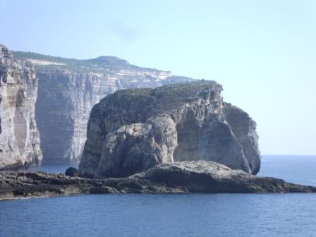
The most notable feature is the Azure Window, a large hole carved out of the surrounding limestone by the action of the waves over thousands of years. It is framing Amy in the background of this photo. You are strongly discouraged from climbing on top of it, but you can walk down to the base if you even realize that is where the little path across the rocks is taking you. If you don’t take this little walk you will never get to see the Blue Hole. I had heard mention of it and assumed it was referring to the Azure Window again. Wrong.

The Blue Hole, shown below, is a deep hole carved out vertically from the rock near the base of the Azure Window. In speaking to a diver I discovered it is connected to the sea by an underwater channel approximately 16 meters down from the surface. The hole itself is some 22 meters deep. After you get more than 10 meters deep there is very little light filtering through the water from above which must make for a really interesting passage to the sea.

Near the parking area for the Azure Window you see an unremarkable, little, puddle-sized bit of water. It is populated by a group of boats that are dense enough to almost fill the surface. Can’t be much going on there, right? Wrong. This is referred to in grandiose terms as the Inland Sea. It isn’t much to look at until you head down and discover that it is connected to the open sea by a small passage through the rock. You can hire a boat and go out through the hole to see the Azure Window from the other side. It would seem to be a smaller version of the Azure Window. Who knows, in several thousand years it might be "the" window while the other opening is totally gone.

The last natural feature is on the other side of the parking area. It is a small island in Dwejra Bay which is called Fungus Rock. It doesn’t look like a fungus, so the name isn’t descriptive in that way. So, what is it? Apparently, the Knights of St. John discovered a very rare plant that grew only there which they felt had significant medicinal powers. Setting foot on the rock while it was under their rule could net you three years rowing in the galleys. Modern pharmacologists have discovered that the plant (not actually a fungus) has no medicinal properties.
Following our time in Dwejra, we headed back to Mgarr and boarded the ferry back to Malta,
Saturday, April 7, 2012
Gozo
Before our recent trip I have to admit that I wasn’t aware that Malta was an archipelago with at least three inhabited islands. Malta, Gozo and Comino are all connected by ferries. The main ferry port is in Cirkewwa at the northern tip of the main island although you can also leave from Valletta as well. The trip to Gozo is free; you only pay to return. You can make the 25 minute trip as a foot passenger, or take your car across. We opted to bring our own transportation. Amy has traveled by ferry with her Mini Cooper to maritime Canada, but this was my first time taking a car onto a boat.

After the ferry docked at Mgarr we made our way directly to Ggantija which I blogged about earlier.
Next we drove to Victoria, parked and visited the Citadel, a small, fortified portion of the city. Parking in Victoria was …. interesting. Amy first attempted an underground parking garage. After winding our way into the bowels of the earth on a one lane ramp where the traffic flow was dictated by traffic lights, we decided it wasn’t such a good place to be and escaped to find a lucky space at the main bus terminal.

The Citadel is home to four more sites under Heritage Malta control and I used the last of my 48 hour Malta Pass to visit the Old Prison. It would seem that Gozo was the place where prisoners from Malta were sent to do their time. Knights who were awaiting trial were allowed to roam free on the island, those who had been found guilty of offenses such as dueling were housed in a six cell prison. Given that this was 3-400 years ago, the conditions were actually quite good. They had ample rations and were checked out weekly by a doctor, daily if they were actually found to be ill. Prisoners often were sentenced to hard labor and it was prisoners who excavated much of the ruins at Ggantija.

Part of the Citadel has been allowed to go to ruin.

Other parts are being extensively worked on.

Once time had run out on our Malta Passes, we made our way to Marsalforn for a lovely and relaxing lunch at a tiny restaurant by the sea. We had our pick of half a dozen nearly empty places and chose one at random which turned out to be excellent. The owner pointed us on our way to Calypso’s Cave which, alas, had been badly water damaged and was no longer open to the public. We opted not to stop in to visit any of the dozens of churches we passed. It is jokingly said that while Malta is 98% Catholic, Gozo is 200%. There certainly were enough churches to easily hold double the population of the island, but I don't think that is what they were referring to.

After the ferry docked at Mgarr we made our way directly to Ggantija which I blogged about earlier.

Next we drove to Victoria, parked and visited the Citadel, a small, fortified portion of the city. Parking in Victoria was …. interesting. Amy first attempted an underground parking garage. After winding our way into the bowels of the earth on a one lane ramp where the traffic flow was dictated by traffic lights, we decided it wasn’t such a good place to be and escaped to find a lucky space at the main bus terminal.

The Citadel is home to four more sites under Heritage Malta control and I used the last of my 48 hour Malta Pass to visit the Old Prison. It would seem that Gozo was the place where prisoners from Malta were sent to do their time. Knights who were awaiting trial were allowed to roam free on the island, those who had been found guilty of offenses such as dueling were housed in a six cell prison. Given that this was 3-400 years ago, the conditions were actually quite good. They had ample rations and were checked out weekly by a doctor, daily if they were actually found to be ill. Prisoners often were sentenced to hard labor and it was prisoners who excavated much of the ruins at Ggantija.

Part of the Citadel has been allowed to go to ruin.

Other parts are being extensively worked on.

Once time had run out on our Malta Passes, we made our way to Marsalforn for a lovely and relaxing lunch at a tiny restaurant by the sea. We had our pick of half a dozen nearly empty places and chose one at random which turned out to be excellent. The owner pointed us on our way to Calypso’s Cave which, alas, had been badly water damaged and was no longer open to the public. We opted not to stop in to visit any of the dozens of churches we passed. It is jokingly said that while Malta is 98% Catholic, Gozo is 200%. There certainly were enough churches to easily hold double the population of the island, but I don't think that is what they were referring to.
Friday, April 6, 2012
Valletta
As I mentioned yesterday, when the Knights of St. John came to Malta they decided that the city of Mdina, while strongly fortified and easily defended, was not the optimal place to headquarter themselves. So, they set about building a new, fortified city at the harbor. Malta’s double harbor is the largest deep water port in the Mediterranean.

The Knights came into existence as a hospital order during the Crusades, only later picking up a military role in the defense of Jerusalem. They were driven out of Jerusalem, settled in and were driven out of Rhodes then wandered until they took up residence on Malta. They must have had considerable wealth given the extent of the city they managed to build. The Knights gave up Malta to Napoleon with barely a fight in 1798. The French had a far shorter tenure, being driven out of Malta a scant two years later by Lord Nelson as he pursued Napoleon.

Entry by car to Valletta is strictly controlled. You can go there, but you are charged steeply by the hour and an administrative fee is added on top. So, armed with maps, guidebooks and passes we drove in to Sliema, across the harbor from Valletta, found a place to park and partook of a traditional English breakfast as we passed the time until the boat trip around Valletta Harbor was ready to leave. Our Malta pass included both the harbor boat tour and a bus tour of the island. The 90 minute boat trip provided a great overview of the history and layout of Valletta. The harbor itself is a vibrant, busy, working harbor with the largest drydock in the Mediterranean, a huge grain silo, warehousing and a cruise ship port. You can go to Sicily in an hour and a half on a high speed catamaran direct from Valletta.

After our boat trip we set out on the hop on hop off tour bus of the island, only intending to take it as far as downtown Valletta. We saw the rest of the island on our own from our car. In Valletta we wandered, stopping first at the Co-Cathedral of St. John. It was founded by the Knights of St. John and each of the knights contributed to it as part of their initiation.

The interior of the church is quite opulent as knights from different countries vied to outdo one another. Inside the church are the pictures of St. Jerome and the Beheading of John the Baptist by Caravaggio.

After seeing the cathedral we attempted to visit the Palace Staterooms and Armory, but they were unexpectedly closed for some state function.
We ended the day at the Manoel Theater, one of the oldest theaters in Europe.

After our guided tour of the theater including a look backstage we took a water taxi back to the Sliema Ferry Terminal, picked up our car from the parking garage and headed back to our hotel.
Thursday, April 5, 2012
Mdina
During Roman times and earlier, the principal city of Malta was not Valletta. Valletta claimed that title later with the arrival of the Knights of St. John. No, the original capital of Malta was actually Mdina, also called during different periods Melita and Medina. Mdina is a fortified hilltop city. It seems the Maltese were partial to building on top of hills to take advantage of the natural protection they provided, much like the hill towns of the area where we live in Italy. The current population of Mdina is approximately 300 although another 11,000 live in the contiguous town of Rabat outside of the fortifications.

The city is all about defense. As you approach the non-cliff side from Rabat and the Domvs Romana you encounter a deep, wide dry moat that is currently occupied by a citrus grove. Restoration of the moat is underway, presumably in anticipation of the celebration of the European Cultural Capital in 2018.

The inner city is accessed by a bridge which spans the moat, leading to an ornately decorated opening. Once inside you encounter a maze of narrow, winding streets. The intention was having no single length longer than one could shoot an arrow.

The narrow width of the streets makes it difficult to appreciate the baroque architecture until you reach the main square of the city where St. Paul’s Cathedral is located.


St. Paul is an important figure in Malta as he was shipwrecked there on his way to Rome by a ferocious storm and then spent time preaching to and converting the locals he found there. He must have done a good job laying the foundations of faith, as Malta is 98% Catholic with a much higher proportion observant than here in Italy.

The cathedral is quite nice inside with the entire floor made of inlaid marble memorials covering the floor. I enjoyed this one of the Grim Reaper.

Subscribe to:
Posts (Atom)